 Photo: Hurtuv · CC BY-SA 3.0
Alentejo Castles & Wine
Cross from Évora and Monsaraz to Estremoz, Marvão and Castelo de Vide on a four- or five-day circuit.
- Allow
- 4–5 days
- Route
- 565 km
- Drive time
- 6 hr 59 min
- Stops
- 6
East of Lisbon, the Alentejo opens into long horizons punctuated by walled towns. Évora provides the cultural anchor, Monsaraz looks over the Alqueva reservoir, Estremoz rises in marble country and Marvão crowns the São Mamede range near the Spanish border.
The driving is generally calm, but heat and distance change the calculation. Avoid midsummer afternoons, fuel before remote sections and book wineries with a designated driver or local transport. The route’s pleasure is spaciousness, not speed.
The road, in one glance
Pinch or scroll with Ctrl / ⌘ to zoom
Drawing the route…
The route earns
its distance
Each pin is selected as a place to do something—not merely proof that you passed through.
 Photo: Vitor Oliveira from Torres Vedras, PORTUGAL · CC BY-SA 2.0
Lisbon
Cross the Tagus after the city stay with toll setup and a first-night booking already clear.
Lisbon ( LIZ-bən; Portuguese: Lisboa ) is the capital and most populous city of Portugal, with an estimated population of 658,236 as of 2025, within its administrative limits and 3,353,000 within the metropolis, as of 2025. The city lies in the western portion of the Iberian Peninsula, on the northern shore of the River Tagus.
 Photo: François Philipp from Darmstadt, Germany · CC BY 2.0
Évora
Roman temple, cathedral, university streets and whitewashed lanes make the UNESCO city a two-night base.
Évora, officially the Very Noble and Ever Loyal City of Évora, is a city and a municipality in Portugal. It has 53,591 inhabitants (2021), in an area of 1,307.08 square kilometers (504.67 mi2). It is considered the historic capital of the Alentejo region and serves as the seat of the Évora District.
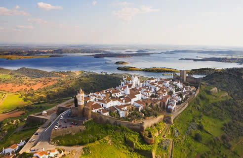
Photo: Hurtuv · CC BY-SA 3.0Monsaraz
A tiny walled ridge town looks across the Alqueva, vineyards and the Spanish frontier.
Monsaraz is a civil parish (freguesia) of the municipality of Reguengos de Monsaraz, on the right margin of the Guadiana River in the Portuguese Alentejo region, near its border with Spain. The population in 2011 was 782, in an area of 88.29 km2.
 Photo: PhillipC [2] · CC BY 2.0
Estremoz
White marble, a castle tower and a strong market tradition shape this northern Alentejo town.
Estremoz is a municipality in Portugal. The population in 2011 was 14,318, in an area of 513.80 km2. The city Estremoz itself had a population of 7,682 in 2001.
 Photo: Krzysztof Żwirski · CC BY 2.5
Marvão
Walls and a castle occupy a granite ridge high above São Mamede Natural Park.
Marvão, officially the Very Noble and Ever Loyal Town of Marvão, is a municipality in Portalegre District in Portugal. The population in 2020 was 2,972 (and dropping at a rate of around one inhabitant per week), in an area of 154.90 km2. The present Mayor is Luís Vitorino, elected by the Social Democratic Party.
 Photo: Concierge.2C · CC BY-SA 3.0
Castelo de Vide
Fountains, steep lanes and a historic Jewish quarter create a softer final base below Marvão.
Castelo de Vide is a whitewashed Alentejo hill town beneath a ruined medieval castle near the Spanish frontier. Its steep Jewish quarter, old synagogue, fountains and tiled lanes reward a slow walk between the higher fortress and the lower civic centre.
Drive the conditions,
not the itinerary.
Carry water and fuel margin, avoid peak heat and appoint a sober driver for every wine visit. Historic hill cores are for walking.
Checked against
the people who run it
Distances and driving times are planning estimates. Conditions, closures, ferries, permits and park rules can change, so check the linked official guidance before setting out.